- AU TAS UTAS SPARC P6-27-111
- Item
- n.d.
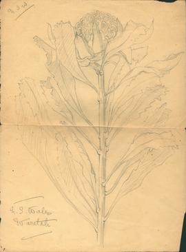
Part of Olive Pink Collection
Pencil sketch of a Waratah, NSW
Olive Pink
Part of Olive Pink Collection
Pencil sketch of a Waratah, NSW
Olive Pink
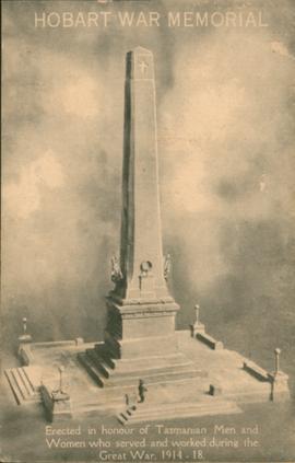
Part of George Musgrave Parker : Correspondence and research records
Postcard of the Hobart War Memorial inscribed Erected in honour of Tasmanian Men and Women who served and worked during the Great War, 1914-18
George Musgrave Parker
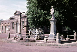
Part of Arthur Knight Slides
Colour photograph shows the Ross War Memorial
Arthur Knight
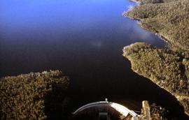
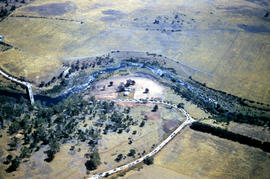
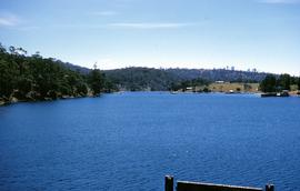
Wall of Clark Dam and Lake King William
Part of Hal Wyatt Collection
Colour aerial photograph of Clark Dam and Lake King William
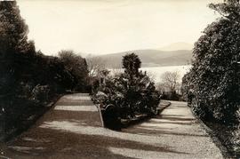
Walking path in Royal Botanical Gardens
Part of Photographs of Edward Verrell
Black-and-white photograph shows gravel walking path in Royal Botanical Gardens

Walkers setting out on track near Dove Lake
Colour photograph shows walkers setting out on track near Dove Lake below Cradle Mountain
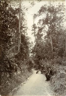
Walkers resting on track to Fern Tree
Part of Photographs of Edward Verrell
Black-and-white photograph shows three men and a dog sitting or standing beside a track to Fern Tree
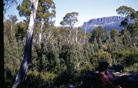
Walkers rest in bush below Mount Olympus
Part of Arthur Knight Slides
Colour photograph shows snow on Mount Olympus
Arthur Knight
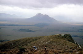
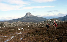
Walkers on ridge overlooking Mount Solitary
Part of Arthur Knight Slides
Colour photograph shows some bushwalkers on a ridge overlooking the valley towards Mount Solitary
Walkers on Mountains of Jupiter
Part of Arthur Knight Slides
Colour photograph of bushwalkers at Mountains of Jupiter near the Walls of Jerusalem
Part of Arthur Knight Slides
Colour photograph of two walkers trying to avoid slippery pathway with flecks of snow on ground and Barn Bluff in background
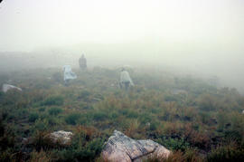
Part of Arthur Knight Slides
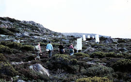
Colour photograph shows three walkers on heathland climbing in fog
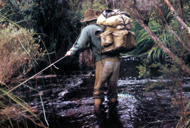
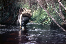
Part of Arthur Knight Slides
Colour photograph shows bushwalker with backpack wading through Sandfly Creek
Walkers carrying roofing iron to K Col
Part of Arthur Knight Slides
Colour photograph shows bushwalkers carrying roofing iron along a path to the ridgeline of K Col near Mount Field West as part of project to build a hut to shelter bushwalkers and skiers. Hobart Walking Club's F.A. Peterson Memorial Hut was opened in 1960
Walkers carrying building materials to K Col
Part of Arthur Knight Slides
Colour photograph shows walkers carrying building materials to build a hut to shelter bushwalkers
Part of Hal Wyatt Collection
Colour photograph shows people walking on gravel track at Crotty, 1963.
Hal Wyatt
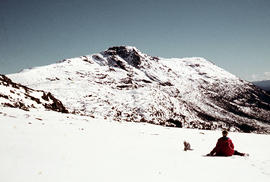
Walker sits on snow near Naturalist Peak
Part of Arthur Knight Slides
Colour photograph shows person sitting on the snow near Naturalist Peak
Part of Arthur Knight Slides
Colour photograph shows a bushwalker fighting to stay upright in the current while fording Sandfly Creek
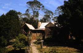
Colour photograph shows new shingle roof and restored timber work on Waldheim Chalet at Cradle Mountain
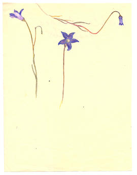
Part of Olive Pink Collection
Watercolour on paper sketched by Olive Pink, Northern Territory, 1930. Identified by Olive Pink as Wahlenbergia gracilis
Olive Pink
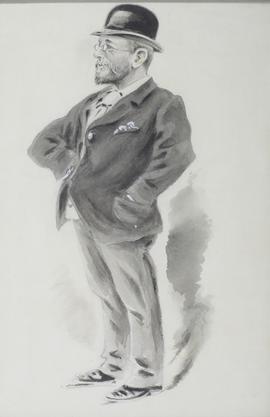
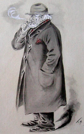
Part of Midwood Collection
Framed caricature of W. Watchorn, merchant, Elizabeth St., Hobart. Senior partner in the firm of Watchorn Bros.
Thomas Claude Wade Midwood
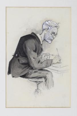
Part of Midwood Collection
Framed caricature of W. Morling. He hired boats at the Bellerive ferry.
Thomas Claude Wade Midwood
Part of Midwood Collection
Framed caricature of W. Baker, a senior official in the Public Works Department.
Thomas Claude Wade Midwood
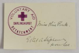
Voluntary Aid Detachment Darlinghurst membership card
Part of Olive Pink Collection
Voluntary Aid Detachment Darlinghurst membership card (Miss Olive Pink) signed by Hon. Sec. Ethel A. Stephens dated 1915
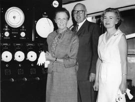
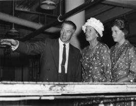
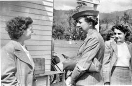
Visitors to the Cadbury factory, pictured standing in front of pressure valves and other display dials.
Visitors to Cadbury Factory, men wearing suits and ties, women in floral summer dresses, hats and carrying bags and gloves
Colin Dennison (Curator)
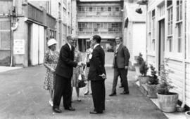
Two women being shown through Cadbury Factory, members of a visiting group including the Governor of Tasmania
Colin Dennison (Curator)
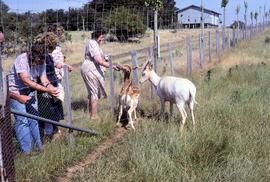
Visitors feeding fallow deer at Thorpe Farm, Bothwell
Colour photograph shows deer being offered food by visitors to Thorpe Farm, where fallow deer is farmed by the Bignell family, Bothwell.
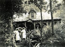
Visitors at Falls Hut, Mount Wellington
Part of Photographs of Edward Verrell
Black-and-white photograph shows visitors standing on front steps and veranda at Falls Hut, built 1897, at the Cascades, on road to Mount Wellington

Visitors at Brickendon, Longford
Part of Hal Wyatt Collection
Colour photograph shows two sightseers, man with camera hanging on strap around his neck and gloved woman carrying handbag, outside main house at Brickendon, historic 465ha estate established and farmed by William Archer and descendants since 1824, who invited tourists to their property from the late 20th century.
Hal Wyatt
Several women outside wooden building, one wearing a hat and gloves. Possible golf game being played in distance.
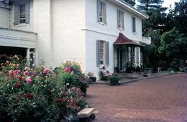
Visitor seated near front door and garden at Brickendon
Part of Hal Wyatt Collection
Colour photograph shows a woman seated on park bench outside main house at Brickendon, historic 465ha estate established and farmed by William Archer and descendants since 1824, who invited tourists to their property from the late 20th century.
Hal Wyatt
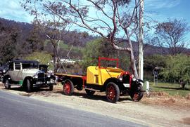
Vintage cars by the Huon River
Part of Hal Wyatt Collection
Colour photograph of two vintage cars parked on roadside verge, near Huon River.
Hal Wyatt
Villarroel, Enrique Gajardo "Chile, el Tratado Antartico y su sistema" Boletin Antartico Chileno
Government statement relevant to Chilean Antarctic policy, Antarctic program operations. Provides document and source information.
Bill Bush
Views on Antarctica submitted by Australia to the Secretary-General of the United Nations, 91 pages.
Part of National Antarctic documents
Government report relevant to United Nations, UN Question of Antarctica, Malaysia. Provides copy of document or extract, with source information. [Published by Bush as AU31071984]
Bill Bush
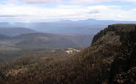
View towards Barn Bluff and Cradle Mountain from Devils Gullet
Colour photograph shows view from Devils Gullet Lookout towards Cradle Mountain and Barn Bluff with earthworks surrounding Fisher Power Station on hill in foreground
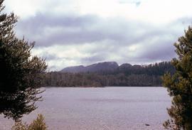
View to Mount Olympus across Lake St Clair
Colour photograph shows Mount OIympus in distance across Lake St Clair
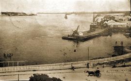
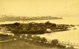
View over Strahan Wharf towards Regatta Point, Strahan, Macquarie Harbor, Tasmania
Part of Images of West Coast Tasmania
Image possibly taken from original glass plate. Shows traffic in the foreground, the wharf and vessels. Original identifying text in the lower right corner.
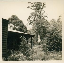
Part of Olive Pink Collection
Black and white photograph of view outside of the gate at Olive Pinks flat in Ferntree, Hobart, Tasmania
Olive Pink
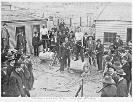
View of woodchoppers Burge and Garcie preparing for competition, Queenstown Tasmania
Part of Images of West Coast Tasmania
Image likely taken from a newspaper and has a partial printed legend at the bottom: 6 T. Garcie, of Strahan (left) v W . Burge, of Crotty (right). Won by Burge.
View of water across Barnes Bay 1960
Part of Hal Wyatt Collection
Colour photograph taken 1960 of Barnes Bay, Bruny Island, showing water and coastline, farmland across bay
Hal Wyatt
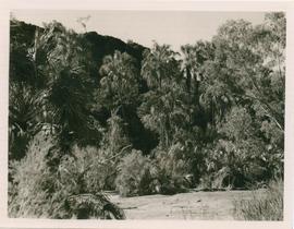
Part of Olive Pink Collection
Black and white photograph of view of valley with palms
Olive Pink
Part of Images of West Coast Tasmania
Image is identified as "Camp at Timbs Landing".
Part of Arthur Knight Slides
Colour photograph shows The Watcher
Part of Images of West Coast Tasmania
Image likely sourced from a newspaper or publication as it has a printed legend at the bottom.
View of the smelters under construction at Crotty, Tasmania
Part of Images of West Coast Tasmania
Image clearly shows the smelters in the foreground. Image is oval and slightly cropped.
Colin Dennison
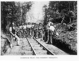
View of the rail (tram) terminus at Comstock, near Zeehan, Tasmania
Part of Images of West Coast Tasmania
Image likely sourced from newspaper or publication as it provides a printed legend at the bottom. Image shows workers standing on the rail line with shovels.
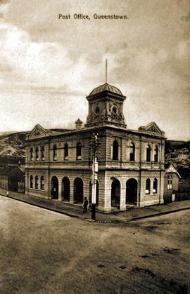
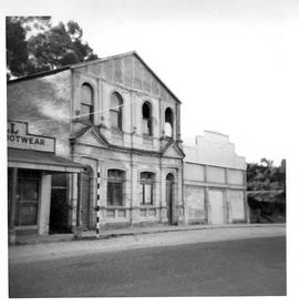
View of the Post Office, Queenstown, Tasmania
Part of Images of West Coast Tasmania
Image contains text identifying the subject. Possibly originally a post card.
Part of Arthur Knight Slides
Colour photograph shows man standing on a ridge on Mount Lord, looking across the Lawrence valley, where the Lawrence Rivulet flows. Man is standing amid tall specimens of Pandani, Richea pandanifolia.
Part of Images of West Coast Tasmania
Image is likely sourced from a newspaper or publication as it shows legend at the bottom identifying the scene and providing technical information.
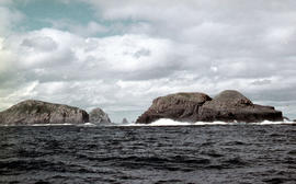
View of the Friars, off South Bruny Island
Part of Arthur Knight Slides
Colour photograph of Friars island group
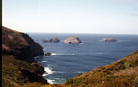
View of the Friars from shore near Pine Log Bight
Part of Arthur Knight Slides
Colour photograph of the Friars, a small group of islands, off southern shore of Bruny Island, taken from shore near Pine Log Bight.
View of the façade of the Commercial Bank, Strahan, Tasmania
Part of Images of West Coast Tasmania
Image possibly taken from original glass plate. Shows traffic in the foreground, the wharf and vessels. Original identifying text in the lower right corner.
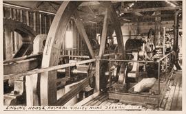
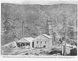
View of the engine house, Austral Valley Mine, Zeehan, Tasmania
Part of Images of West Coast Tasmania
Image has hand printed label giving title and date in bottom.
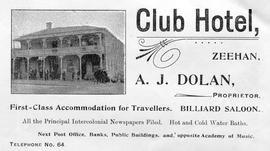
View of the Club Hotel, Zeehan, Tasmania
Part of Images of West Coast Tasmania
Image is an advertisement with the Hotel in the centre and text above and below providing the name, address, proprietor and telephone number.
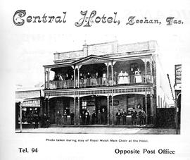
View of the Central Hotel, Zeehan, Tasmania
Part of Images of West Coast Tasmania
Image is an advertisement with the Hotel in the centre and text above and below providing the name, address, proprietor and telephone number. Image also records that the "Photo taken during stay of Royal Welsh Male Choir at the Hotel."
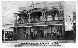
View of the Central Hotel, Zeehan, Tasmania
Part of Images of West Coast Tasmania
Image likely sourced from a newspaper or publication as it has a printed legend at the bottom stating that the "Photo taken during stay of Royal Welsh Male Choir at the Hotel." Label added later identifying the subject and date.
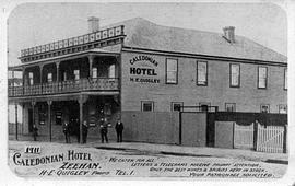
View of the Caledonian Hotel, Zeehan, Tasmania
Part of Images of West Coast Tasmania
Image is likely an advertising card as text is printed on the image providing details of services, address and proprietors name. An additional label giving the date has been added to the image later.
Part of Images of West Coast Tasmania
Image is likely sourced from a newspaper or publication as it shows legend at the bottom identifying the scene and providing technical information about the mine.
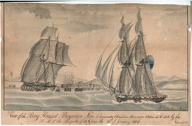
Part of Lane Papers
View of the brig 'Harriot', Benjamin Lane commander chased onshore near Calais at 6am by his BMS the 'Misqueter' of 18 guns on 30 January 1806. Water colour sketch showing two ships sailing; one carrying guns and flying the British blue ensign, and the other unarmed nearer the shore and some of the crew apparently about to land by rowing boat. Harbour and gun battery and houses in the background. Signed 'B. Lane, Great Yarmouth'. Note in corner: Verdun.
Benjamin Lane
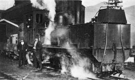
View of the Beyer Peacock Steam engine at Silver Bell, near Zeehan, Tasmania
Part of Images of West Coast Tasmania
Image has the engine dominant with two male figures to the left. Image is grainy.
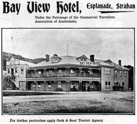
View of the Bay View Hotel, Strahan, Tasmania
Part of Images of West Coast Tasmania
Image is an advertisement, either a flyer or from a publication and shows the Hotel in the centre and two street frontages. Bayview Hall shown to the left and pedestrians on the street.
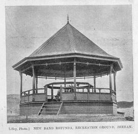
View of the Band Rotunda, Zeehan, Tasmania
Part of Images of West Coast Tasmania
Image has hand printed label giving title and date in bottom.
Lilley
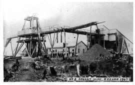
View of the Argent Mine Number 2, Zeehan, Tasmania
Part of Images of West Coast Tasmania
Image has hand printed label giving title and date in bottom right.
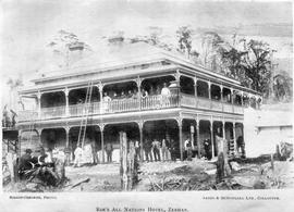
View of the All Nations Hotel, Zeehan, Tasmania
Part of Images of West Coast Tasmania
Image is likely sourced from a newspaper or publication as it shows title at the bottom: Roe's All Nations Hotel, Zeehan. It also identifies the photographer and states "Sands & McDougall Ltd Collotype". The view is very early as there are tree stumps in the foreground.
Bishop-Osbourne
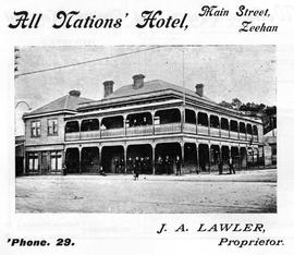
View of the All Nations Hotel, Zeehan, Tasmania
Part of Images of West Coast Tasmania
Image is an advertisement with the Hotel in the centre and text above and below providing the name, address, proprietor and telephone number.
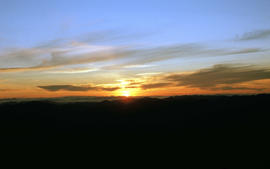
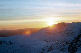
View of sunset from Rodway Range
Part of Arthur Knight Slides
Colour photograph shows sunset as viewed from Rodway Range
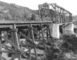
View of steel railway bridge with adjacent timber trestle extension, Crotty, Tasmania
Part of Images of West Coast Tasmania
Image shows the bridge in good condition making the dating difficult. Image quality tends to suggest a later date.

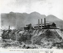
View of steam train on trestle bridge likely at the smelting works, Crotty, Tasmania.
Part of Images of West Coast Tasmania
Image likely sourced from a newspaper or publication as it contains printed legend with hand written amendment at the bottom: Smelter site showing works in course of construction and method of disposing of slag. Mount Jukes in the background. Crotty 1898.
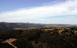
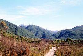
Colour landscape photograph of heavily forested area at Staverton and Cethana, in the Kentish Municipality, near Sheffield, Tasmania.

View of snow on Mount Wellington from Huon Road
Part of Photographs of Edward Verrell
Black-and-white photograph shows snow on Mount Wellington viewed from the verge of the Huon Road, South Hobart, with post-and-rail fence alongside roadway.
View of snow on ground at Reeds Peak and nearby lakes
Part of Hal Wyatt Collection
Colour aerial photograph of Reeds Peak with lakes in foothills
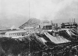
View of smelters showing construction works and slag disposal at Crotty, Tasmania.
Part of Images of West Coast Tasmania
Image shows close up of the smelters. A vertical shadow crossing the image is visible in the left third of the image.
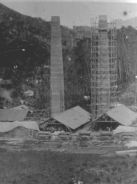
View of smelters at Crotty, Tasmania.
Part of Images of West Coast Tasmania
Image shows one chimney stack under scaffolding and other buildings under construction.
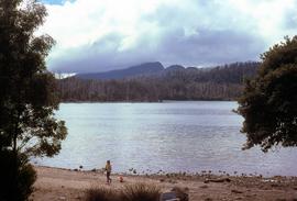
View of shoreline of Lake St Clair looking to Mount Olympus
Colour photograph shows people on beach of shoreline at Lake St Clair, with cloud cover above Mount OIympus in distance
View of shoreline at base of Cape Connella, looking down cliff face
Part of Arthur Knight Slides
Colour photograph of shoreline at base of Cape Connella, South Bruny Island, looking down the cliff face.
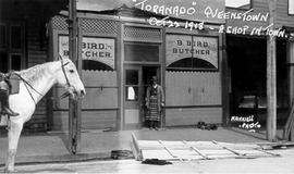
View of shop, B Bird Butcher with proprietor outside, Queenstown Tasmania
Part of Images of West Coast Tasmania
Image shows street scene with partial images of adjacent shops. B Bird Butcher's shop depicted, with man in apron standing in doorway, dog on footpath nearby, plus horse under saddle standing in road. Contains contemporaneous hand written text 'Toranado' (sic) Queenstown Oct 22 1918 - A shop in town. The Photographer's name is also on the image, in the same script 'Nankivell'. Toranado may refer to a storm experienced by the town in October 1918 and described as a tornado.
View of Sherwood, homestead in Clyde River Valley
Colour photograph of sandstone homestead, Sherwood, with nearby outbuildings, willows lining the banks of nearby Clyde River at Hollow Tree
Colour photograph of sandstone homestead, Sherwood, with farm outbuildings and Clyde River Valley
Part of Arthur Knight Slides
Colour photograph shows Russell Falls as viewed from elevated vantage point in rainforest
Part of Hal Wyatt Collection
Colour aerial photograph of snow-topped ridge of Reeds Peak
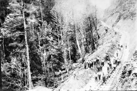
View of railway line under construction, Queenstown Tasmania
Part of Images of West Coast Tasmania
Image has a steam engine and many mining carriages standing beside a steep hillside denuded of vegetation. Many men carrying shovels stand around, apparently working on the site. Image possibly connected to Mt Lyell mining operations.
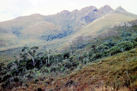
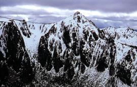
View of mountain ranges west of Mt. Lord
Part of Arthur Knight Slides
Colour photograph of mountain ranges west of Mt. Lord
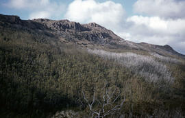
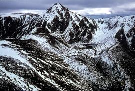
View of Mount Mawson from Florentine Peak saddle
Part of Arthur Knight Slides
Colour photograph shows Mount Mawson viewed from saddle of Florentine Peak, with partial snow cover
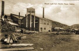
View of Mount Lyell Co's Electric Power Station, Queenstown Tasmania
Part of Images of West Coast Tasmania
Image is slightly out of focus and contains text identifying the subject. Possibly originally a post card.
View of Mount Jukes from site of former Crotty smelters
Part of Hal Wyatt Collection
Colour photograph shows three people standing on a former industrial site at Crotty, in front of Mount Jukes, a rocky mountaintop with heavily timbered foothills.
Hal Wyatt
View of Mount Huxley near Crotty
Part of Hal Wyatt Collection
Colour photograph of Mount Huxley and Crotty at sunset, 1970.
Hal Wyatt
View of Mount Field West from Florentine Peak
Part of Hal Wyatt Collection
Colour photograph of Mount Field West from Florentine Peak 1966
View of motor vehicles outside the Queenstown Hotel, Queenstown, Tasmania
Part of Images of West Coast Tasmania
Image centres on the two motor vehicles and adjacent figures, showing the ground and part of the first storey of the Queenstown Hotel. Affixed to first-storey railing is a large banner promoting Newtown v Queenstown football match on Saturday August 6th.
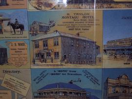
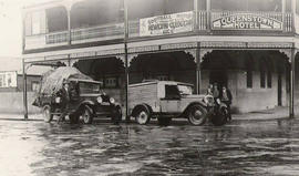
View of Montagu Hotel, Bowes street Queenstown Tasmania
Part of Images of West Coast Tasmania
Image is only one of a number of businesses on a colour advertising sheet. Others shown include Royal Hotel and JB Wood, hairdresser.
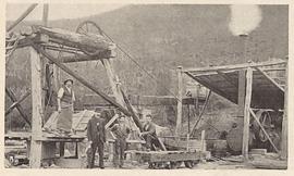
View of mine works at Comstock, near Zeehan, Tasmania
Part of Images of West Coast Tasmania
Image shows men standing beside winches, rail carts and other aspects of the mining operations.
Colin Dennison
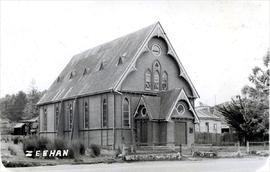
View of Methodist church in Carpenter Gothic Style, Zeehan, Tasmania
Part of Images of West Coast Tasmania
Image has "Zeehan" in hand writing in the lower left corner.
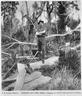
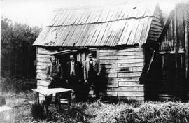
View of male axeman standing on fallen timber in the bush, Crotty, Tasmania.
Part of Images of West Coast Tasmania
Image likely sourced from a newspaper or publication as it contains printed legend at the bottom: Opening out of the west - clearing the land for the new town of Crotty. Photographer identified. Primitive buildings just visible in the background. It is likely the image is older than 1902.
F.E. Pousty
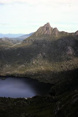
View of Little Horn of Cradle Mountain and Dove Lake
Colour photograph of Little Horn and Dove Lake, Cradle Mountain
View of lighthouse at Cape Bruny
Part of Arthur Knight Slides
Colour photograph of Bruny Island lighthouse looking south
View of Lake St Clair from Mount Manfred
Part of Arthur Knight Slides
Colour photograph shows motor boat on Lake Trevallyn
Arthur Knight
View of hills around Crotty 1970
Part of Hal Wyatt Collection
Colour photograph shows track cut into foothills at Crotty, 1970.
Hal Wyatt
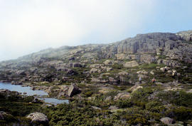
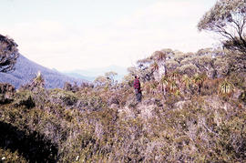
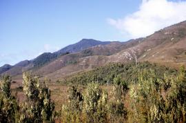
View of heathland near Mount Bowes
Part of Arthur Knight Slides
Colour photograph shows heathland looking southwest from near Mount Bowes
View of Dunkleys Point at Sandy Bay
Part of Photographs of Edward Verrell
Black-and-white photograph shows Sandy Bay Road in foreground, the grand home St Helena on what is known as Dunkleys Point, and Battery Point on the opposite shore of the bay
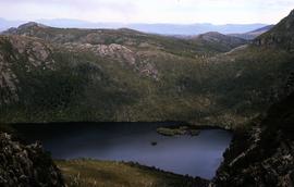
View of Dove Lake and Honeymoon Island
Colour photograph shows Honeymoon Island in Dove Lake, near Cradle Mountain